

Super Typhoon Ragasa has reached rarified, new heights this weekend.
Reaching sustained winds of 270 km/h for a short time, the feat makes Ragasa––currently located northeast of Manila, Philippines–the strongest storm on Earth in 2025 so far.
DON’T MISS: The high-stakes factors that decide where a hurricane tracks
That firmly places Ragasa at a Category 5-equivalency using the Saffir-Simpson scale, the highest possible category. It currently has significant wave heights of 11-12 metres (38 feet).
Advertisement
Advertisement
#_R_kkt56mhak5clubsnm6fbH1_ { display: none; }
@media screen and (max-width: 767.95px) {
#_R_kkt56mhak5clubsnm6fbH1_ { display: flex; }
iframe { max-width: 100vw; }
}
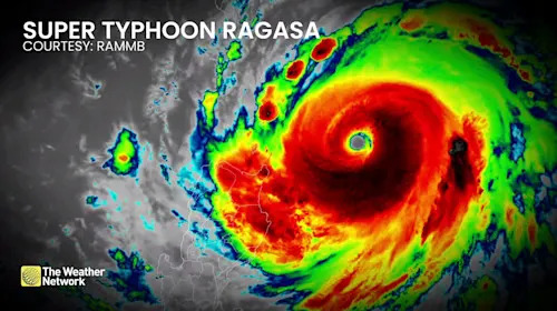
Satellite imagery shows a compact, clear eye with highly symmetrical banding, a strong indication of a very mature, extreme hurricane.
Super Typhoon Ragasa satellite imagery/RAMMB/NOAA
Super Typhoon Ragasa satellite imagery. (RAMMB/NOAA)
Top five of the strongest storms of 2025 (one-minute maximum of sustained winds)
-
Super Typhoon Ragasa: 270 km/h (Category 5) on Sept. 21
-
Cyclone Errol: 260 km/h (Category 5) on April 16
-
Cyclone Vince: 250 km/h (Category 4) on Feb. 7
-
Typhoon Neoguri: 235 km/h (Category 4) on Sept. 21
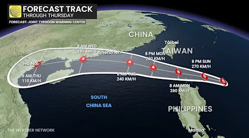
Super Typhoon Ragasa forecast track through Thursday
Why is it so strong?
There are a few reasons why Ragasa has grown to its monstrous strength.
-
The storm has almost no wind shear to disrupt the storm’s core.
-
Sea surface temperatures are near 30°C
-
Healthy storm outflow in all directions (storm symmetry)
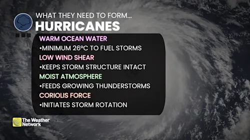
What hurricanes need to form explainer
Super Typhoon Ragasa is expected to maintain close to peak intensity for the next 12 hours, before gradually weakening as it brushes by the Philippines and moves towards the South China Sea.
Thumbnail courtesy of RAMMB/NOAA.


