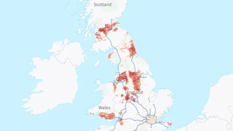
Although most of the coal mines in Britain are now closed down, their workings and shafts remain below ground. These are quite extensive. During the industrial revolution, from around 1750 to 1850, hundreds of mines were sunk, to power steam engines and other newly-developed machines like the Spinning Jenny, which produced fabric. In 1750, Britain was producing 5.2 million tons of coal per year. By 1850, it was producing 62.5 million tons per year. The seams became attenuated in the early part of the 20th century and gradually the mines became non-viable. The industry went into a steep decline from the 1960s and the last of the deep mines was closed in 2015.
These extensive former coal mine workings exist across much of Great Britain and it is estimated by the Coal Authority that 25% of homes and businesses in the UK are located around these mine workings. Water within the old mines is warmed by natural processes and can, if sustainably managed, provide a continuous supply of geothermal energy. Mine water temperatures are not affected by seasonal variations and this water could provide renewable, secure, low carbon heating for buildings in coalfield adjacent areas.
Most of the surface machinery and buildings were demolished and the entry to the mines sealed up, for obvious safety reasons. The land is now often used for new residences or businesses. Not all of the mine shaft information is documented or up to date. Ordnance Survey (OS) – the official UK mapping agency – and the Coal Authority have joined up to map the potential supply and demand of heat from water in disused coal mines throughout Great Britain.
Utilizing the UK’s National Geographic Database, OS provided the Coal Authority with geospatial support as well as location and address data to conceptualize what areas of the UK could benefit from this extensive disused mine network. Initial results showed that there are just over six million homes and over 300,000 offices and businesses above abandoned coal mines. This is just a preliminary survey to scope out what geothermal resource could be made available. The UK needs additional power capacity as the need for electricity could exceed the supply generated in future.
“Our data has been used to support the effective mapping of heating and cooling demand across the coal workings areas, providing a way to quickly understand and analyze the distribution of infrastructure and development and seeing which areas could benefit most from the initiative,” said John Kimmance, managing director of National Mapping Services at OS.“This project has reinforced the critical role that location data plays in supporting sustainability projects and highlights how we can drive change for the future.”
Finding new sources of energy is clearly a challenge, as is meeting the government’s decarbonization targets. So any viable source of energy that can be brought into the grid mix would be very useful.
A pilot project in the North of England, at Gateshead, is trialing the concept of heating from mine water. 350 homes, council and privately-owned offices, a college and an arts center, are tapping into this geothermal heat source. “We know from schemes, such as the recently commissioned Gateshead mine heat network, that this works in the UK,” said Richard Bond, the Coal Authority’s Innovation and Engagement director. “The wider associated benefits of low carbon heat, leveling up, green jobs and energy security will be very positive for Great Britain in many ways.”
Location data is fundamental to finding the right places to access mine water. This new map will help located geothermal resources, as well as clarifying which mine workings might be postential power sources and which are not viable.


