

During high-water events like last week’s king tide, Marin County’s densest neighborhood begins to drown.
Near the harbor, saltwater trickles out from under an apartment building and swamps a restaurant patio, finding cracks in foundations and cement walls put up to staunch it. It inches up the tires of parked cars and pools over evacuation routes. Multistory buildings loom like islands.
This San Rafael neighborhood, home to 12,000 people, is the Bay Area’s most vulnerable to sea level rise, for a multitude of reasons. It perches over a canal leading to the San Francisco Bay, and parts of it were originally built on soil added to fill in the wetlands and bay itself – a topography that is causing it to sink even as the ocean and bay rise. Even in the immediate term, a large earthquake or a huge, 100-year storm combined with a high tide could create inundation by several feet, experts say.
Advertisement
Advertisement
“People aren’t necessarily aware that this is happening and the risks that are present,” said Rita Mazariegos, a member of a community sea level rise steering committee, who spoke in Spanish through an interpreter. She said displacement is a constant worry. “There is not enough affordable housing here, and so the moment (a flood) happens, it’s a grave situation for everyone that lives here.”
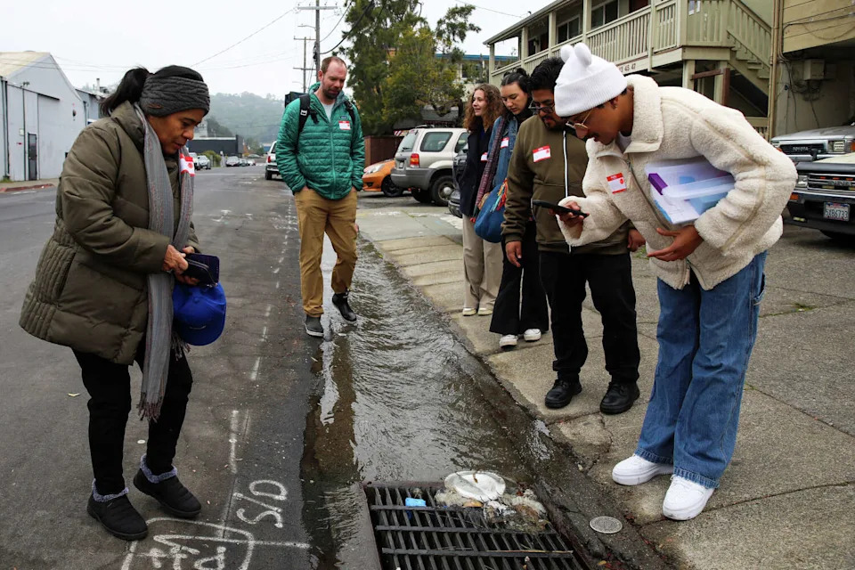
Community member Raquel Sanchez, left, looks at a storm drain along with volunteers Kevin Befus (green coat), associate professor at University of Arkansas, Amélie Bernex, and Angela Gil, UC Berkeley civil and environmental engineering students, community member Javier Jose, and Walter Gonzalez, management analyst with the City of San Rafael, on Harbor St. during a king tide event organized by Canal Alliance in San Rafael on Dec. 6. (Yalonda M. James/S.F. Chronicle)
The area of San Rafael, called the Canal District, is the Bay Area’s densest neighborhood after Chinatown. It is also the most segregated: Predominantly Latino and working-class, it is one of Marin’s few low-income areas. Most of the land and buildings along the channel are privately owned, leaving no room to build seawalls or levees to defend against both emergency floods and the long-term threat of climate change.
“All these adaptation options would involve putting something between the bay and the urban area. But right now that’s not possible,” said Kate Hagemann, climate adaptation and resilience planner for the city of San Rafael.
Advertisement
Advertisement
One immediate problem is that the neighborhood’s two main exit roads are lower than the highest tide. Already prone to tidal flooding, they are expected to become permanently inundated by 2050, according to the Transportation Authority of Marin’s recent sea level rise study, which suggested elevating the roadways.
Consultants published a draft feasibility study in October for the city with alternative options to consider for protecting the shoreline and surrounding neighborhood. One alternative would involve the government purchasing up to 86 of the more than 100 private properties that line the shoreline, or at least buying easements on them, in order to build shoreline protection, and then selling the land back to private developers. That route could take at least two decades to complete, at a cost of $211 million for the property acquisitions, the study found.
“All of that is seven steps in the future,” said Hagemann, who previously had a similar role in Miami-Dade County. San Rafael is exploring the options while asking the community for feedback, she said. “By no means is a choice being made at the moment.”
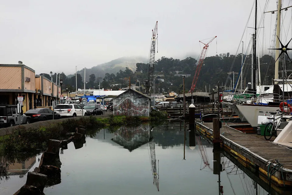
The San Rafael Creek is seen during a king tide on Dec. 6. The Canal District is highly vulnerable to sea level rise. (Yalonda M. James/S.F. Chronicle)
The study also presents ideas for immediate fixes, such as raising areas along the canal above the current highest tide and upgrading pump stations that are already overwhelmed at high tides – and only designed to deal with rainwater, not seawater. Along with other long-term strategies like building levees, the adaptations could cost an estimated $719 million to $1.9 billion. The city would likely need to bring in outside funding and would be responsible for at least 35% of any project that received federal support, according to the study.
Advertisement
Advertisement
Such fixes can’t come soon enough, community members say, because flooding is already a chronic problem. Mazariegos’ husband lost his car to floodwaters two decades ago. Raquel Sanchez, who lived in the Canal District for 20 years, said water filled parking areas during rainstorms, dampening her car’s interior. Moisture seeped into the house she shared with her sons, blooming into mold on the walls and infusing her clothes with mildew.
“When I changed to a different building I thought it would be better. It had the same problem,” said Sanchez, who moved three times within the neighborhood and has since relocated just outside of it.
In addition to being the home of mostly working class residents, thousands of people have jobs in the neighborhood at places like a wastewater treatment plant and recycling center, which are also vulnerable, said Hagemann.
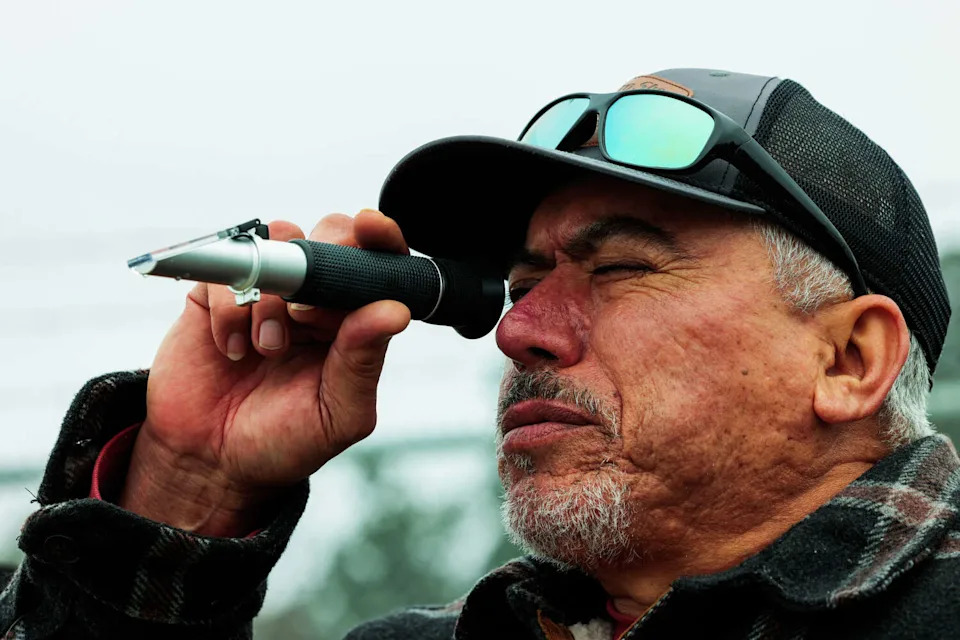
Using a salinometer, community member Jose Arce reads the salinity level from a water sample taken from San Rafael Creek during a king tide event organized by Canal Alliance in San Rafael, Calif. on Dec. 6 Residents of the Canal District collected data, measured water levels, documented their site visit as part of a citizen science project intended to educate residents about flood risk and be more informed. (Yalonda M. James/S.F. Chronicle)
“The scale is really large,” said Isabel French, director of marketing and communications at Canal Alliance, a nonprofit offering legal and other services to Latino immigrants. “And it’s not a future problem, it’s a right now problem.”
Advertisement
Advertisement
The Bay Conservation and Development Commission, the state agency that oversees sea level rise planning in the San Francisco Bay, found that San Rafael has the highest proportion of people at risk of flooding from early sea level rise impacts, compared to 30 other areas around the region, in a 2020 vulnerability study.
“In most places around the bay there’s maybe 20 years to patch cracks in the bathtub,” said Kristina Hill, a professor at UC Berkeley’s Department of Landscape Architecture & Environmental Planning, referring to the vulnerability of the shoreline as sea levels rise. “In San Rafael, the bathtub is already really cracked. They maybe have 10 years to really patch the cracks.”
According to the city, parts of eastern San Rafael have sunk by several feet in areas built over fill, and some areas are expected to subside 2 to 4 more feet in coming decades. Like many parts of the Bay Area, much of it was built on bay mud soil or areas where construction waste or other material was used to fill former wetlands and parts of the bay.
Sea levels have risen 3 inches in the past 25 years and are expected to rise another foot in the coming 25 to 45 years. That is considered a tipping point when, if nothing is done, economic losses could reach $130 million to $210 million, according to the feasibility study. By that point, the canal would overtop barriers once a month, which would “disrupt regular function” in the area, “through regular flooding of vehicles, salt corrosion of infrastructure, business disruption, market perception of risk and potential collapse in real estate values,” the study said.
Advertisement
Advertisement
“We’re going to be living in this time of incremental flooding events that get worse and worse and worse. They’ll seem like small disasters but eventually the water won’t go away,” said Hill, whose graduate students just finished a class devoted to finding solutions for both short- and long-term flood risk in the Canal District, including from an earthquake, which they found could lead to flooding during a high tide by disabling pumps and knocking over informal barriers.
Hill was encouraged by the city and county’s purchase of 1.6 acres in the neighborhood last month to build a much-needed park: They spent $3.35 million with the help of private partners like the Canal Alliance. The city will explore the idea of building a pedestrian bridge from the park to connect the neighborhood better to other parts of the city.
Hills’ students envisioned using the new space, and other existing parks, as emergency hubs, with storage for tents and other supplies, she said.
If roads were elevated, they could later be transformed into levees, Hill’s students suggest, when more protection is needed from rising seas.
Advertisement
Advertisement
The city and county must build more low-income housing for the region’s workforce in a less vulnerable area, Hill said, but the Canal District does not have to be abandoned. Buildings in the flood zone can be redesigned to be floodproof on the first floor, as is done in Humboldt County, or to float, as in the Netherlands, she said.
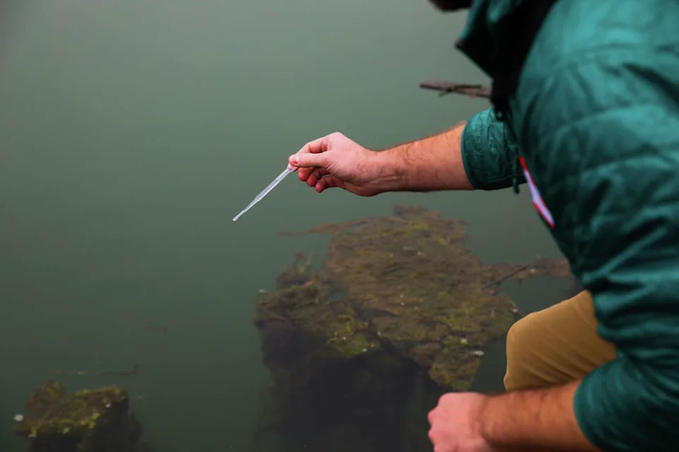
Kevin Befus, associate professor at University of Arkansas, collects a water sample from San Rafael Creek during a king tide event organized by Canal Alliance in San Rafael on Dec. 6. (Yalonda M. James/S.F. Chronicle)
But Marin County has many other places to protect along its bayshore, said Michael Wara, the director of the Climate and Energy Policy Program at Stanford University and a Marin County resident.
“The only solutions are going to involve really intensive engineering,” he said. “There’s going to be places where Marin has the money to defend and places where it’s not going to be able to defend.”
Advertisement
Advertisement
The Canal District lies within the jurisdiction of San Rafael, so the city is responsible for raising funding, but the county can advocate for it when it applies for state and federal funding – though the latter has been scarce lately, which is making getting state funding more competitive, said Talia Smith, interim deputy county executive.
The county is working on creating a more unified approach to the problem for the eight jurisdictions that lie along the county’s bayshore, including unincorporated areas – similar to the organization called OneShoreline in San Mateo County, Smith said.
That way, she said, “We don’t have the county competing with San Rafael.”
This article originally published at The Bay Area neighborhood most vulnerable to sea level rise is also sinking: ‘A right now problem’.